
Announcements
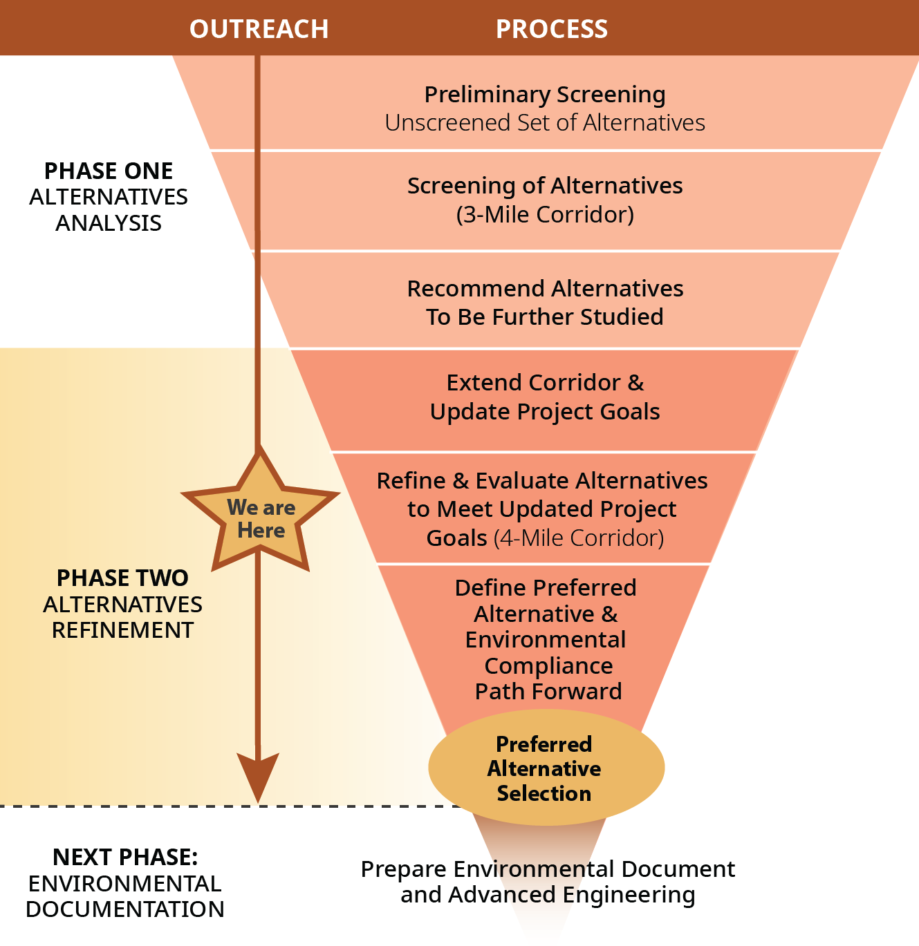
We are excited to reengage with the community after gathering input during the first phase of this project. In this phase, our aim is to identify a Preferred Alternative by refining and reevaluating alternatives to meet the updated project goals, which now include extending the total project study area to a 4-mile stretch, through Mission Road, from N. Soto Street to N. Main Street.
Take our online survey HERE by May 12th for a chance to win a $50 gift card.
Project Overview
Quick Links: Project Resources | Interactive Map
The Huntington Drive Multi-Modal Transportation Improvement Project will transform and improve the Huntington Drive corridor for all modes of transportation, including vehicle, bus, bicycles and pedestrians with enhanced access to commercial businesses, residential neighborhoods, educational facilities, recreational centers and industrial properties. LABOE in partnership with CM de León (Council District 14), plan to improve vehicular circulation, upgrade transit service and ridership, enhance bicycle and pedestrian safety and access, and integrate modern technology and travel options. Through this project, Huntington Drive would thus become a high-quality regional mobility corridor connecting various Eastside communities to Downtown Los Angeles.
The project benefits include:
- Improve mobility for all roadway users, including vehicles, bicyclists, and pedestrians
- Improve traffic flow and enhance safety
- Create open space
- Improve transit speed & reliability
- Support a thriving local economy
Study Corridor
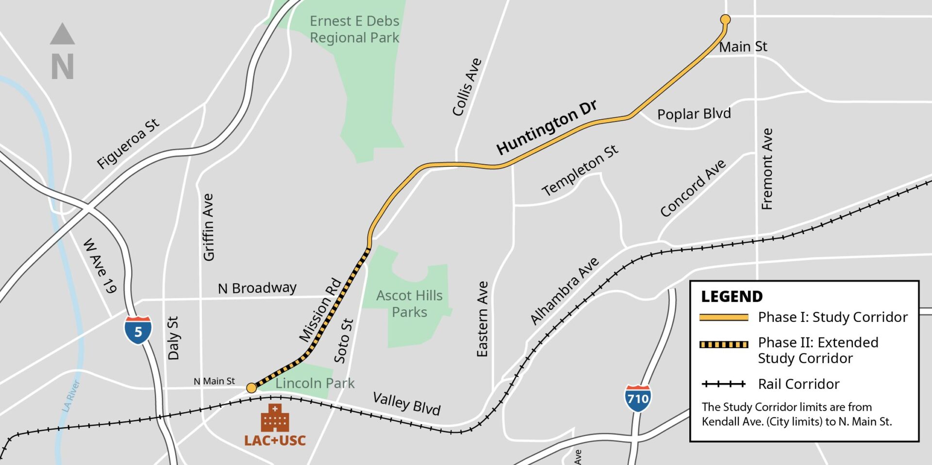
LA METRO has formally increased the project limits to include the extended study corridor along North Mission Road from Soto Street to N. Main Street. This segment will be included in the environmental analysis in the next phase of the project.
Project Gallery
-still")
The Project Phases
Phase I (2021-2022)
- 3-mile corridor feasibility study conducted from Soto Street to Kendall Avenue at the City limit.
- Initial community survey issued in summer 2021, receiving nearly 700 responses.
- Common themes: expansion of safe pedestrian amenities, increased bus shelter and sidewalk improvements (including ADA accessibility), and safer bike lanes
- Two key objectives identified: expansion of open space along the corridor and reevaluation of project assumptions and community needs.
Phase II (2023-2024):
- Aims to identify a Preferred Alternative by refining and reevaluating alternatives to meet updated project goals.
- Project study area extended to a 4-mile stretch along Mission Road, from N. Main Street to N. Soto Street.
- Summer 2024 outreach engagement efforts include: an additional community survey and two public meetings for gathering valuable community feedback
Next Phase
- Includes Project Approval & Environmental Document, advanced engineering, and implementation strategies.
- Addresses how to implement and build preferred corridor concept.
The final multi-modal alternative will be developed in accordance with current, City design standards, requirements, and proposed project goals.
The Planning Process
Below are documents and links related to the project.
- Existing Conditions
- Fact Sheet
- Community Meetings
- June 1st, 2022
- August 31st, 2021
- Survey Results
- 3-Mile Corridor Alternative
Phase I (2021 – 2022)
Interactive Map
Quick Links: Project Overview | Project Resources | Back to Top
The Huntington Drive Multi-Modal Transportation Improvement Project is a four-mile stretch connecting the City of Alhambra and South Pasadena to North Mission Road near LAC+USC Medical Center. This section of Huntington Drive is a heavily trafficked, three-lane north-bound and south-bound roadway that serves residential, commercial, institutional, recreational and industrial land uses the Huntington Drive corridor from Kendall Avenue (City limits) to N. Soto Street will be two lanes of travel in each direction, repurposing one lane of travel in each direction for pedestrian, bicycle, transit and streetscape functions.